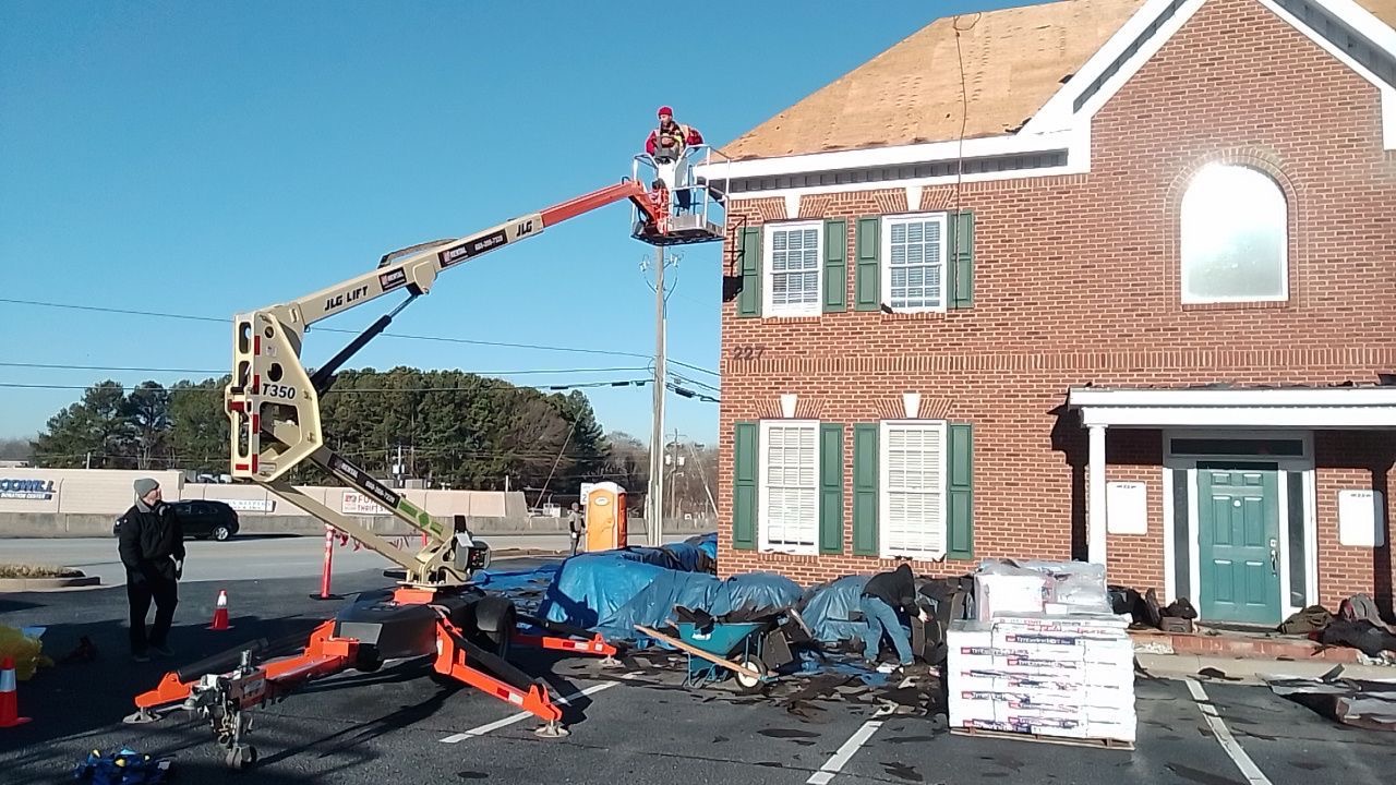
For most of the history of roofing, inspecting a roof meant one thing: someone climbed a ladder, walked the surface, and reported what they saw. That method works, but it carries real limitations. An inspector can only examine what is safe to reach, can only photograph from the angles their footing allows, and — on a steep estate roofline or a slick algae-covered slope — may not be able to reach significant areas at all. Their weight on already-compromised shingles can knock loose granules and worsen the very damage they came to assess.
Drone inspection changed that. A roofing-grade unmanned aircraft carries a high-resolution sensor over every square foot of a roof, capturing imagery at consistent angles and resolutions that a person standing on the surface could never replicate. For an Atlanta market where homes routinely feature complex two-story rooflines, multiple dormers, steep traditional pitches, and the storm-damage patterns that come with the Southeast's hail and wind, aerial inspection has become the documentation standard rather than a novelty.
This guide explains how drone roof inspections actually work — the equipment, the flight workflow, the imaging technology — and, more importantly, why they consistently surface damage that a ground inspection or a quick foot walk would miss. Whether you are documenting storm damage for an insurance claim, planning a replacement, or simply want to know the true condition of your roof, understanding what aerial inspection captures helps you evaluate what you are being shown.
1. What a Drone Roof Inspection Actually Is
A drone roof inspection uses a small remotely piloted aircraft, equipped with a stabilized high-resolution camera, to photograph and sometimes video-record a roof from above and around its perimeter. The aircraft flies a deliberate pattern over each roof plane, hovering where needed to capture close detail and rising for context shots that show how the planes, valleys, and penetrations relate to one another. The result is a complete, organized photographic record of the roof's condition at a specific moment in time.
The important distinction is that this is not casual photography. A professional aerial roof inspection is a structured data-gathering process. The pilot follows a coverage pattern that ensures no plane is missed, holds consistent altitude and angle for comparable imagery, and captures both wide context and tight detail. On larger estate properties, the imagery is often stitched into a single high-resolution composite or a measured model that lets the inspector take accurate dimensions directly from the photographs.
For homeowners considering a roof replacement or evaluating possible storm damage, the practical takeaway is this: a drone inspection produces evidence you can review yourself. Rather than taking a verbal description of "some wear on the back slope," you see annotated, date-stamped imagery of the exact condition being described.
2. The Equipment: Aircraft, Sensors, and What They Capture
Roofing drones are purpose-suited industrial tools, not hobbyist toys. The aircraft itself prioritizes flight stability in wind — important in metro Atlanta, where gusty afternoon conditions are common — along with GPS-assisted positioning that lets the pilot hold a precise hover and repeat a coverage pattern reliably. Battery cycles run roughly 20 to 35 minutes, so larger properties are documented across multiple flights.
The sensor is where the inspection value lives. Modern roofing drones carry cameras in the 20 to 48 megapixel range with optical or hybrid zoom, which is what enables sub-inch detail from a safe standoff distance. At that resolution, an inspector reviewing the imagery can distinguish a hail bruise — a circular depression where the granule surface has been knocked loose and the mat beneath bruised — from ordinary granule loss caused by age. That distinction is the entire basis of a wind-and-hail insurance claim, and it is far harder to make confidently from a ground-level photo or even a hurried foot inspection.
Two additional sensor capabilities matter for thorough assessment. Thermal imaging detects temperature differences across the roof surface that can indicate trapped moisture or insulation gaps — a technique closely related to infrared and thermal leak detection, which finds water intrusion before it becomes visible damage. Photogrammetry stitches dozens of overlapping images into a dimensionally accurate model, allowing the roof area, pitch, and material quantities to be measured directly from the imagery rather than estimated from the ground.
3. How the Flight and Workflow Actually Work
A professional aerial inspection follows a repeatable sequence. The pilot begins with a site survey — confirming airspace conditions, noting obstacles such as power lines and tall trees common on wooded Atlanta lots, and planning a flight path that gives full coverage. In controlled airspace near the city's airports, the operation requires FAA authorization, which a properly credentialed operator secures in advance.
Once cleared, the flight proceeds methodically. The aircraft typically captures a high orbit first for context, then descends to document each roof plane in turn at consistent altitude and overlap. Areas of interest — a suspect valley, a chimney flashing, a lifted ridge cap — get dedicated close-detail passes. The pilot watches the live feed throughout, returning to anything that warrants a second look. This is the moment where aerial inspection separates from a foot walk: the inspector can revisit any spot instantly, from any angle, without repositioning a ladder or risking their footing.
After landing, the imagery is reviewed on a calibrated screen far larger and sharper than a phone or a glance in the field. Suspect conditions are annotated, measurements are extracted from the model, and the findings are organized into a report. For a homeowner pursuing an insurance claim, this organized, date-stamped, geotagged record is exactly what an adjuster needs to validate the scope and timing of damage.
Aerial inspection captures evidence you can review yourself. Instead of a verbal description of roof condition, you receive annotated, date-stamped imagery of every plane — the same record an insurance adjuster uses to validate a claim. Seeing the actual condition removes the guesswork from your decision.
4. Why Drones Find Damage Ground Inspections Miss
The central claim of this article deserves direct support: aerial inspection consistently surfaces damage that a ground inspection or a quick foot walk overlooks. There are several concrete reasons, and none of them depend on the drone being "smarter" than a good inspector. They depend on access, angle, and resolution.
Complete coverage of unreachable planes. Atlanta's larger homes — particularly in Buckhead and Alpharetta — frequently feature steep traditional and craftsman rooflines, three-story sections, and surfaces that cannot bear foot traffic. An inspector physically cannot reach all of it. A drone documents every plane regardless of pitch or height, so back slopes and high dormers that would otherwise go undocumented are captured in full.
Consistent angle and resolution. A person walking a roof photographs from a few feet away at awkward, inconsistent angles. A drone holds a controlled standoff and captures comparable imagery across the entire surface, which makes patterns visible — a consistent line of wind-lifted tabs along a windward edge, a uniform field of hail strikes across the south slope — that piecemeal ground photos would never reveal as a pattern.
No inspector weight on compromised material. Walking a roof that already has loose granules, brittle aged shingles, or hidden deck rot risks causing damage and creating a safety hazard. Aerial imaging assesses the surface without touching it, which is the only responsible way to evaluate fragile slate, tile, and storm-weakened asphalt.
The pattern recognition that supports causation. Insurance claims hinge on distinguishing storm damage from age and wear. Aerial imagery reveals directional damage patterns — hail bruising concentrated on the slopes facing the storm's approach, wind damage along specific exposures — that establish a weather event as the cause. Scattered ground photos rarely tell that story convincingly.
5. Drone Inspection vs. Traditional Foot Inspection
Both methods have a place, and the strongest assessments combine them. The comparison below lays out where each approach excels and where it falls short, so you understand what a complete inspection actually requires.
| Factor | Drone Aerial Inspection | Traditional Foot Inspection |
|---|---|---|
| Surface coverage | 100% of all planes, regardless of pitch or height | Limited to safely reachable areas |
| Safety | No one on the roof; zero fall risk | Fall hazard; risk increases on steep or wet surfaces |
| Damage to roof | None — no contact with the surface | Foot traffic can loosen granules or crack tile |
| Documentation quality | High-resolution, geotagged, date-stamped, measurable | Inconsistent angles; depends on inspector's phone |
| Tactile verification | Cannot feel soft decking or test fastener grip | Direct contact confirms soft spots and movement |
| Time on site | 10–20 minutes for a standard home | Longer, especially on complex or steep roofs |
| Best use | Full documentation, claims, steep and high roofs | Confirming specific suspect areas hands-on |
The honest reading of this comparison is that aerial imaging wins decisively on coverage, safety, and documentation, while a targeted foot inspection retains one irreplaceable advantage: touch. You cannot feel whether decking has gone spongy or whether a fastener has lost its grip from a photograph. That is precisely why 1Source treats the drone as the primary documentation tool and the hands-on check as the confirmation step on anything the imagery flags.
6. Drone Inspection After an Atlanta Storm
Metro Atlanta sits squarely in the Southeast's severe-weather corridor. Spring brings the region's most active hail season, summer delivers intense thunderstorm wind, and the remnants of Gulf and Atlantic tropical systems periodically push damaging gusts inland. After any of these events, the speed and completeness of documentation directly affect how a claim resolves.
The advantage of drone documentation immediately after a storm is twofold. First, it establishes the date. A geotagged, time-stamped set of aerial images taken within days of a hail event makes the timing of the damage difficult to dispute — far stronger evidence than ground photos taken weeks later, when an adjuster can question whether the damage predates the storm. Second, it captures the directional pattern that proves causation, showing hail concentrated on storm-facing slopes and wind damage along exposed edges.
For homeowners navigating the claim itself, the value compounds. A complete aerial record lets the contractor's damage documentation align line-for-line with the adjuster's scope, which is the single most reliable way to prevent underpayment. When the contractor and the adjuster are looking at the same comprehensive imagery, disputes over what is and is not damaged largely disappear. Pair this with an understanding of how RCV and ACV policies pay, and you walk into the claim process prepared rather than reactive.
Document Your Roof Before You Decide Anything
Free on-site assessment with aerial imaging where it adds value. See the actual condition of your roof in high-resolution detail — no obligation.
Call (404) 277-13777. Why Aerial Inspection Matters Most on Atlanta Estate Homes
The case for drone inspection grows stronger as a roof gets larger and more complex — and metro Atlanta's luxury market is full of exactly the rooflines where aerial imaging is the only thorough option. A sprawling two-story traditional in Johns Creek with multiple wings, a steep estate roof in Sandy Springs, or a craftsman with stacked dormers in Roswell presents acres of surface that no inspector can fully walk.
On these properties, foot inspection is not merely difficult — it is incomplete by definition. The high back slopes, the upper dormer faces, and the steep transitions simply cannot be reached and documented from the surface without unacceptable risk. Aerial imaging covers all of it, and the photogrammetric measurement it produces lets a roofer scope a precise material quantity for these large, geometrically demanding roofs rather than estimating.
For premium homes that may carry synthetic slate, natural slate, or standing seam metal, the no-contact nature of aerial inspection is itself a benefit. These materials are damaged by foot traffic. Documenting their condition from the air protects the very surface being assessed. When the goal is a thorough, defensible record of a high-value roof, aerial imaging is not a convenience — it is the appropriate professional standard.
8. Drone Inspection on Commercial and Low-Slope Roofs
Aerial inspection is equally valuable beyond residential work. Large commercial roofs — flat or low-slope membranes covering tens of thousands of square feet — are time-consuming and often hazardous to inspect on foot, with rooftop equipment, skylights, and ponding areas to navigate. A drone documents the entire field quickly and safely, and thermal imaging is especially powerful on these systems for locating trapped moisture beneath the membrane before it becomes a leak.
For property managers and building owners, this speed and completeness translate into better decisions. A drone survey can map exactly where a membrane is degrading, where seams are failing, and where moisture has entered, supporting a targeted restoration coating rather than a premature full replacement. Regular aerial documentation also underpins a disciplined roof asset management program, creating a dated visual history that tracks how a roof is aging across a portfolio of buildings.
9. The Specific Conditions Aerial Imaging Reveals
It helps to know exactly what a trained reviewer looks for in aerial imagery. The list below covers the conditions that aerial inspection documents particularly well — many of which are difficult to assess reliably from the ground.
- Hail bruising and granule loss: circular impact marks where granules are knocked loose and the mat is bruised, distinguishable from age-related granule wear.
- Wind-lifted and creased shingles: tabs broken from their self-seal bond, often along a consistent windward line.
- Flashing separation and failure: gaps at chimneys, walls, and skylights where step or reglet flashing has pulled away.
- Failed pipe boots: cracked or split pipe boot seals, one of the most common leak sources.
- Valley wear and debris: deterioration and blockage in the most water-concentrated areas of the roof.
- Ventilation issues: ridge vent condition and signs of inadequate airflow visible across the field.
- Algae streaking and biological growth: the dark streaks that algae-resistant shingles are designed to prevent.
- Missing or displaced material: entire shingles or ridge caps lost to wind, immediately visible from above.
Undocumented storm damage rarely stays small. A wind-lifted tab or a hail-bruised slope that goes unrecorded today becomes water intrusion, deck rot, and a far larger project within a season or two. Aerial documentation immediately after a storm captures the damage while it is still repairable — and while the claim is still clean.
10. The Honest Limits of Drone Inspection
No responsible discussion of this technology is complete without its boundaries, because a contractor who claims aerial imaging replaces every other method is overselling. The single most important limitation is the absence of touch. Imagery shows the surface in extraordinary detail, but it cannot tell you whether the decking beneath a stained area has gone soft, whether a fastener has backed out, or whether a shingle that looks intact has lost its adhesive grip. Confirming those conditions requires a hand on the roof.
Weather and airspace also impose practical limits. Sustained high wind, rain, and low light degrade image quality or ground the aircraft entirely, so inspections are scheduled around conditions. Properties near Hartsfield-Jackson or other controlled airspace require FAA authorization before flight, which a credentialed operator handles but which can affect timing. Heavy tree canopy on a wooded lot can obstruct flight paths and shade portions of the roof.
The right conclusion is not that aerial inspection is flawed, but that it is one half of a complete assessment. The strongest inspection uses the drone to document everything comprehensively and identify suspect areas, then sends a qualified inspector to verify those specific areas by hand. This is the approach that earns the trust of homeowners and adjusters alike, and it is the standard 1Source applies.
11. How 1Source Uses Drone Inspection in Your Assessment
Understanding how a thorough inspection is conducted helps you evaluate any proposal you receive — and recognize the difference between a documented process and a price-first sales pitch that skips the steps that protect you.
Our process begins with a free on-site assessment. Where the property warrants it — a steep or high roofline, a complex estate roof, post-storm damage documentation, or a pending insurance claim — we deploy aerial imaging to capture the entire surface. The pilot flies a complete coverage pattern, documents every plane and penetration, and captures dedicated detail on any suspect area. For properties where a straightforward foot inspection is genuinely sufficient, we say so; the objective is the right tool for your specific home, not technology for its own sake.
From the imagery, we prepare a documented assessment: annotated photographs of any damage, measured dimensions where a replacement is being scoped, and a clear explanation of condition. If aerial review flags a suspect area, a qualified inspector confirms it by hand. This combined record becomes the foundation for a written scope of work — whether that scope is a targeted repair, a full replacement, or supporting documentation for a water damage claim.
For estate homes throughout metro Atlanta and for commercial properties alike, this standard does not change. Thorough aerial documentation, hands-on verification where it matters, and a written scope you can review before any commitment. You can explore more of our completed work in the photo gallery, learn more about our company, or read why homeowners choose 1Source. The free assessment starts the process before any financial decision — because you should see the actual condition of your roof before anyone discusses what to do about it.
Schedule Your Free Drone-Documented Roof Assessment
Complete aerial imaging, hands-on verification, and a written scope — before any commitment. Serving Atlanta, Buckhead, Alpharetta, and all of metro Atlanta.
(404) 277-1377 — No ObligationCertified by Industry-Leading Manufacturers